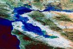
The Space Shuttle view of the San Francisco Bay has clickable red-spot locations of the pictures seen below.
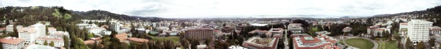
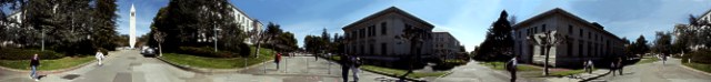
A 360° view from the top of the University of California, Berkeley Campanile. The central pedestrian intersection at the center of Berkeley Campus. A view of Berkeley from the Claremont Ridge Park. A view of Berkeley from the top of the gate at the top of the trail up Claremont Ridge. Coyote Point, Newark, California. The Doe Library lawn on a spring day. The Emeryville train station. A typical view of the San Francisco Bay at sunset from Emeryville. The Emeryville Marina projects almost a mile out into the San Francisco Bay. The Faculty Glade of the University of California, Berkeley. On the beach of San Francisco Bay, at the old Hayward Landing. Hayward State University hillside view of San Francisco Bay. Hayward Japanese Tea Garden, near downtown Hayward. Japanese Tea Garden, Hayward California. The Aircraft carrier Hornet is docked in Alameda, California. Larkspur Landing where the San Francisco Ferry Boats dock. View of Oakland from the Mormon Temple. A view of the San Francisco Bay from the top of Mount Tamalpais. A view from the highway on Mount Tamalpais. Downtown Oakland, California from the freeway. People's Park, near the University of California. The Berkeley Pier, with a plume of smoke rising from the Point Richmond oil refinery. Hilltop above Point Richmond, California. Sproul Plaza on the University of California, Berkeley campus. Another view of the Sproul Plaza, Berkeley, California. The intersection of Telegraph Avenue with Dwight Way in Berkeley, California. Go to Index of Virtually Berkeley
The central pedestrian intersection at the center of Berkeley Campus. A view of Berkeley from the Claremont Ridge Park. A view of Berkeley from the top of the gate at the top of the trail up Claremont Ridge. Coyote Point, Newark, California. The Doe Library lawn on a spring day. The Emeryville train station. A typical view of the San Francisco Bay at sunset from Emeryville. The Emeryville Marina projects almost a mile out into the San Francisco Bay. The Faculty Glade of the University of California, Berkeley. On the beach of San Francisco Bay, at the old Hayward Landing. Hayward State University hillside view of San Francisco Bay. Hayward Japanese Tea Garden, near downtown Hayward. Japanese Tea Garden, Hayward California. The Aircraft carrier Hornet is docked in Alameda, California. Larkspur Landing where the San Francisco Ferry Boats dock. View of Oakland from the Mormon Temple. A view of the San Francisco Bay from the top of Mount Tamalpais. A view from the highway on Mount Tamalpais. Downtown Oakland, California from the freeway. People's Park, near the University of California. The Berkeley Pier, with a plume of smoke rising from the Point Richmond oil refinery. Hilltop above Point Richmond, California. Sproul Plaza on the University of California, Berkeley campus. Another view of the Sproul Plaza, Berkeley, California. The intersection of Telegraph Avenue with Dwight Way in Berkeley, California. Go to Index of Virtually Berkeley
A view of Berkeley from the Claremont Ridge Park. A view of Berkeley from the top of the gate at the top of the trail up Claremont Ridge. Coyote Point, Newark, California. The Doe Library lawn on a spring day. The Emeryville train station. A typical view of the San Francisco Bay at sunset from Emeryville. The Emeryville Marina projects almost a mile out into the San Francisco Bay. The Faculty Glade of the University of California, Berkeley. On the beach of San Francisco Bay, at the old Hayward Landing. Hayward State University hillside view of San Francisco Bay. Hayward Japanese Tea Garden, near downtown Hayward. Japanese Tea Garden, Hayward California. The Aircraft carrier Hornet is docked in Alameda, California. Larkspur Landing where the San Francisco Ferry Boats dock. View of Oakland from the Mormon Temple. A view of the San Francisco Bay from the top of Mount Tamalpais. A view from the highway on Mount Tamalpais. Downtown Oakland, California from the freeway. People's Park, near the University of California. The Berkeley Pier, with a plume of smoke rising from the Point Richmond oil refinery. Hilltop above Point Richmond, California. Sproul Plaza on the University of California, Berkeley campus. Another view of the Sproul Plaza, Berkeley, California. The intersection of Telegraph Avenue with Dwight Way in Berkeley, California. Go to Index of Virtually Berkeley
A view of Berkeley from the top of the gate at the top of the trail up Claremont Ridge. Coyote Point, Newark, California. The Doe Library lawn on a spring day. The Emeryville train station. A typical view of the San Francisco Bay at sunset from Emeryville. The Emeryville Marina projects almost a mile out into the San Francisco Bay. The Faculty Glade of the University of California, Berkeley. On the beach of San Francisco Bay, at the old Hayward Landing. Hayward State University hillside view of San Francisco Bay. Hayward Japanese Tea Garden, near downtown Hayward. Japanese Tea Garden, Hayward California. The Aircraft carrier Hornet is docked in Alameda, California. Larkspur Landing where the San Francisco Ferry Boats dock. View of Oakland from the Mormon Temple. A view of the San Francisco Bay from the top of Mount Tamalpais. A view from the highway on Mount Tamalpais. Downtown Oakland, California from the freeway. People's Park, near the University of California. The Berkeley Pier, with a plume of smoke rising from the Point Richmond oil refinery. Hilltop above Point Richmond, California. Sproul Plaza on the University of California, Berkeley campus. Another view of the Sproul Plaza, Berkeley, California. The intersection of Telegraph Avenue with Dwight Way in Berkeley, California. Go to Index of Virtually Berkeley
Coyote Point, Newark, California. The Doe Library lawn on a spring day. The Emeryville train station. A typical view of the San Francisco Bay at sunset from Emeryville. The Emeryville Marina projects almost a mile out into the San Francisco Bay. The Faculty Glade of the University of California, Berkeley. On the beach of San Francisco Bay, at the old Hayward Landing. Hayward State University hillside view of San Francisco Bay. Hayward Japanese Tea Garden, near downtown Hayward. Japanese Tea Garden, Hayward California. The Aircraft carrier Hornet is docked in Alameda, California. Larkspur Landing where the San Francisco Ferry Boats dock. View of Oakland from the Mormon Temple. A view of the San Francisco Bay from the top of Mount Tamalpais. A view from the highway on Mount Tamalpais. Downtown Oakland, California from the freeway. People's Park, near the University of California. The Berkeley Pier, with a plume of smoke rising from the Point Richmond oil refinery. Hilltop above Point Richmond, California. Sproul Plaza on the University of California, Berkeley campus. Another view of the Sproul Plaza, Berkeley, California. The intersection of Telegraph Avenue with Dwight Way in Berkeley, California. Go to Index of Virtually Berkeley
The Doe Library lawn on a spring day. The Emeryville train station. A typical view of the San Francisco Bay at sunset from Emeryville. The Emeryville Marina projects almost a mile out into the San Francisco Bay. The Faculty Glade of the University of California, Berkeley. On the beach of San Francisco Bay, at the old Hayward Landing. Hayward State University hillside view of San Francisco Bay. Hayward Japanese Tea Garden, near downtown Hayward. Japanese Tea Garden, Hayward California. The Aircraft carrier Hornet is docked in Alameda, California. Larkspur Landing where the San Francisco Ferry Boats dock. View of Oakland from the Mormon Temple. A view of the San Francisco Bay from the top of Mount Tamalpais. A view from the highway on Mount Tamalpais. Downtown Oakland, California from the freeway. People's Park, near the University of California. The Berkeley Pier, with a plume of smoke rising from the Point Richmond oil refinery. Hilltop above Point Richmond, California. Sproul Plaza on the University of California, Berkeley campus. Another view of the Sproul Plaza, Berkeley, California. The intersection of Telegraph Avenue with Dwight Way in Berkeley, California. Go to Index of Virtually Berkeley
The Emeryville train station. A typical view of the San Francisco Bay at sunset from Emeryville. The Emeryville Marina projects almost a mile out into the San Francisco Bay. The Faculty Glade of the University of California, Berkeley. On the beach of San Francisco Bay, at the old Hayward Landing. Hayward State University hillside view of San Francisco Bay. Hayward Japanese Tea Garden, near downtown Hayward. Japanese Tea Garden, Hayward California. The Aircraft carrier Hornet is docked in Alameda, California. Larkspur Landing where the San Francisco Ferry Boats dock. View of Oakland from the Mormon Temple. A view of the San Francisco Bay from the top of Mount Tamalpais. A view from the highway on Mount Tamalpais. Downtown Oakland, California from the freeway. People's Park, near the University of California. The Berkeley Pier, with a plume of smoke rising from the Point Richmond oil refinery. Hilltop above Point Richmond, California. Sproul Plaza on the University of California, Berkeley campus. Another view of the Sproul Plaza, Berkeley, California. The intersection of Telegraph Avenue with Dwight Way in Berkeley, California. Go to Index of Virtually Berkeley
A typical view of the San Francisco Bay at sunset from Emeryville. The Emeryville Marina projects almost a mile out into the San Francisco Bay. The Faculty Glade of the University of California, Berkeley. On the beach of San Francisco Bay, at the old Hayward Landing. Hayward State University hillside view of San Francisco Bay. Hayward Japanese Tea Garden, near downtown Hayward. Japanese Tea Garden, Hayward California. The Aircraft carrier Hornet is docked in Alameda, California. Larkspur Landing where the San Francisco Ferry Boats dock. View of Oakland from the Mormon Temple. A view of the San Francisco Bay from the top of Mount Tamalpais. A view from the highway on Mount Tamalpais. Downtown Oakland, California from the freeway. People's Park, near the University of California. The Berkeley Pier, with a plume of smoke rising from the Point Richmond oil refinery. Hilltop above Point Richmond, California. Sproul Plaza on the University of California, Berkeley campus. Another view of the Sproul Plaza, Berkeley, California. The intersection of Telegraph Avenue with Dwight Way in Berkeley, California. Go to Index of Virtually Berkeley
The Emeryville Marina projects almost a mile out into the San Francisco Bay. The Faculty Glade of the University of California, Berkeley. On the beach of San Francisco Bay, at the old Hayward Landing. Hayward State University hillside view of San Francisco Bay. Hayward Japanese Tea Garden, near downtown Hayward. Japanese Tea Garden, Hayward California. The Aircraft carrier Hornet is docked in Alameda, California. Larkspur Landing where the San Francisco Ferry Boats dock. View of Oakland from the Mormon Temple. A view of the San Francisco Bay from the top of Mount Tamalpais. A view from the highway on Mount Tamalpais. Downtown Oakland, California from the freeway. People's Park, near the University of California. The Berkeley Pier, with a plume of smoke rising from the Point Richmond oil refinery. Hilltop above Point Richmond, California. Sproul Plaza on the University of California, Berkeley campus. Another view of the Sproul Plaza, Berkeley, California. The intersection of Telegraph Avenue with Dwight Way in Berkeley, California. Go to Index of Virtually Berkeley
The Faculty Glade of the University of California, Berkeley. On the beach of San Francisco Bay, at the old Hayward Landing. Hayward State University hillside view of San Francisco Bay. Hayward Japanese Tea Garden, near downtown Hayward. Japanese Tea Garden, Hayward California. The Aircraft carrier Hornet is docked in Alameda, California. Larkspur Landing where the San Francisco Ferry Boats dock. View of Oakland from the Mormon Temple. A view of the San Francisco Bay from the top of Mount Tamalpais. A view from the highway on Mount Tamalpais. Downtown Oakland, California from the freeway. People's Park, near the University of California. The Berkeley Pier, with a plume of smoke rising from the Point Richmond oil refinery. Hilltop above Point Richmond, California. Sproul Plaza on the University of California, Berkeley campus. Another view of the Sproul Plaza, Berkeley, California. The intersection of Telegraph Avenue with Dwight Way in Berkeley, California. Go to Index of Virtually Berkeley
On the beach of San Francisco Bay, at the old Hayward Landing. Hayward State University hillside view of San Francisco Bay. Hayward Japanese Tea Garden, near downtown Hayward. Japanese Tea Garden, Hayward California. The Aircraft carrier Hornet is docked in Alameda, California. Larkspur Landing where the San Francisco Ferry Boats dock. View of Oakland from the Mormon Temple. A view of the San Francisco Bay from the top of Mount Tamalpais. A view from the highway on Mount Tamalpais. Downtown Oakland, California from the freeway. People's Park, near the University of California. The Berkeley Pier, with a plume of smoke rising from the Point Richmond oil refinery. Hilltop above Point Richmond, California. Sproul Plaza on the University of California, Berkeley campus. Another view of the Sproul Plaza, Berkeley, California. The intersection of Telegraph Avenue with Dwight Way in Berkeley, California. Go to Index of Virtually Berkeley
Hayward State University hillside view of San Francisco Bay. Hayward Japanese Tea Garden, near downtown Hayward. Japanese Tea Garden, Hayward California. The Aircraft carrier Hornet is docked in Alameda, California. Larkspur Landing where the San Francisco Ferry Boats dock. View of Oakland from the Mormon Temple. A view of the San Francisco Bay from the top of Mount Tamalpais. A view from the highway on Mount Tamalpais. Downtown Oakland, California from the freeway. People's Park, near the University of California. The Berkeley Pier, with a plume of smoke rising from the Point Richmond oil refinery. Hilltop above Point Richmond, California. Sproul Plaza on the University of California, Berkeley campus. Another view of the Sproul Plaza, Berkeley, California. The intersection of Telegraph Avenue with Dwight Way in Berkeley, California. Go to Index of Virtually Berkeley
Hayward Japanese Tea Garden, near downtown Hayward. Japanese Tea Garden, Hayward California. The Aircraft carrier Hornet is docked in Alameda, California. Larkspur Landing where the San Francisco Ferry Boats dock. View of Oakland from the Mormon Temple. A view of the San Francisco Bay from the top of Mount Tamalpais. A view from the highway on Mount Tamalpais. Downtown Oakland, California from the freeway. People's Park, near the University of California. The Berkeley Pier, with a plume of smoke rising from the Point Richmond oil refinery. Hilltop above Point Richmond, California. Sproul Plaza on the University of California, Berkeley campus. Another view of the Sproul Plaza, Berkeley, California. The intersection of Telegraph Avenue with Dwight Way in Berkeley, California. Go to Index of Virtually Berkeley
Japanese Tea Garden, Hayward California. The Aircraft carrier Hornet is docked in Alameda, California. Larkspur Landing where the San Francisco Ferry Boats dock. View of Oakland from the Mormon Temple. A view of the San Francisco Bay from the top of Mount Tamalpais. A view from the highway on Mount Tamalpais. Downtown Oakland, California from the freeway. People's Park, near the University of California. The Berkeley Pier, with a plume of smoke rising from the Point Richmond oil refinery. Hilltop above Point Richmond, California. Sproul Plaza on the University of California, Berkeley campus. Another view of the Sproul Plaza, Berkeley, California. The intersection of Telegraph Avenue with Dwight Way in Berkeley, California. Go to Index of Virtually Berkeley
The Aircraft carrier Hornet is docked in Alameda, California. Larkspur Landing where the San Francisco Ferry Boats dock. View of Oakland from the Mormon Temple. A view of the San Francisco Bay from the top of Mount Tamalpais. A view from the highway on Mount Tamalpais. Downtown Oakland, California from the freeway. People's Park, near the University of California. The Berkeley Pier, with a plume of smoke rising from the Point Richmond oil refinery. Hilltop above Point Richmond, California. Sproul Plaza on the University of California, Berkeley campus. Another view of the Sproul Plaza, Berkeley, California. The intersection of Telegraph Avenue with Dwight Way in Berkeley, California. Go to Index of Virtually Berkeley
Larkspur Landing where the San Francisco Ferry Boats dock. View of Oakland from the Mormon Temple. A view of the San Francisco Bay from the top of Mount Tamalpais. A view from the highway on Mount Tamalpais. Downtown Oakland, California from the freeway. People's Park, near the University of California. The Berkeley Pier, with a plume of smoke rising from the Point Richmond oil refinery. Hilltop above Point Richmond, California. Sproul Plaza on the University of California, Berkeley campus. Another view of the Sproul Plaza, Berkeley, California. The intersection of Telegraph Avenue with Dwight Way in Berkeley, California. Go to Index of Virtually Berkeley
View of Oakland from the Mormon Temple. A view of the San Francisco Bay from the top of Mount Tamalpais. A view from the highway on Mount Tamalpais. Downtown Oakland, California from the freeway. People's Park, near the University of California. The Berkeley Pier, with a plume of smoke rising from the Point Richmond oil refinery. Hilltop above Point Richmond, California. Sproul Plaza on the University of California, Berkeley campus. Another view of the Sproul Plaza, Berkeley, California. The intersection of Telegraph Avenue with Dwight Way in Berkeley, California. Go to Index of Virtually Berkeley
A view of the San Francisco Bay from the top of Mount Tamalpais. A view from the highway on Mount Tamalpais. Downtown Oakland, California from the freeway. People's Park, near the University of California. The Berkeley Pier, with a plume of smoke rising from the Point Richmond oil refinery. Hilltop above Point Richmond, California. Sproul Plaza on the University of California, Berkeley campus. Another view of the Sproul Plaza, Berkeley, California. The intersection of Telegraph Avenue with Dwight Way in Berkeley, California. Go to Index of Virtually Berkeley
A view from the highway on Mount Tamalpais. Downtown Oakland, California from the freeway. People's Park, near the University of California. The Berkeley Pier, with a plume of smoke rising from the Point Richmond oil refinery. Hilltop above Point Richmond, California. Sproul Plaza on the University of California, Berkeley campus. Another view of the Sproul Plaza, Berkeley, California. The intersection of Telegraph Avenue with Dwight Way in Berkeley, California. Go to Index of Virtually Berkeley
Downtown Oakland, California from the freeway. People's Park, near the University of California. The Berkeley Pier, with a plume of smoke rising from the Point Richmond oil refinery. Hilltop above Point Richmond, California. Sproul Plaza on the University of California, Berkeley campus. Another view of the Sproul Plaza, Berkeley, California. The intersection of Telegraph Avenue with Dwight Way in Berkeley, California. Go to Index of Virtually Berkeley
People's Park, near the University of California. The Berkeley Pier, with a plume of smoke rising from the Point Richmond oil refinery. Hilltop above Point Richmond, California. Sproul Plaza on the University of California, Berkeley campus. Another view of the Sproul Plaza, Berkeley, California. The intersection of Telegraph Avenue with Dwight Way in Berkeley, California. Go to Index of Virtually Berkeley
The Berkeley Pier, with a plume of smoke rising from the Point Richmond oil refinery. Hilltop above Point Richmond, California. Sproul Plaza on the University of California, Berkeley campus. Another view of the Sproul Plaza, Berkeley, California. The intersection of Telegraph Avenue with Dwight Way in Berkeley, California. Go to Index of Virtually Berkeley
Hilltop above Point Richmond, California. Sproul Plaza on the University of California, Berkeley campus. Another view of the Sproul Plaza, Berkeley, California. The intersection of Telegraph Avenue with Dwight Way in Berkeley, California. Go to Index of Virtually Berkeley
Sproul Plaza on the University of California, Berkeley campus. Another view of the Sproul Plaza, Berkeley, California. The intersection of Telegraph Avenue with Dwight Way in Berkeley, California. Go to Index of Virtually Berkeley
Another view of the Sproul Plaza, Berkeley, California. The intersection of Telegraph Avenue with Dwight Way in Berkeley, California. Go to Index of Virtually Berkeley
The intersection of Telegraph Avenue with Dwight Way in Berkeley, California.
Go to Index of Virtually Berkeley